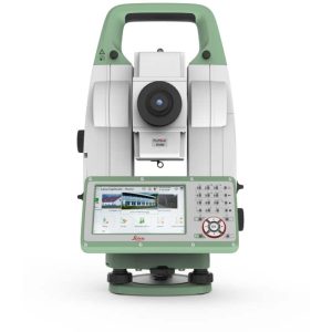
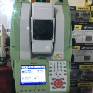
Leica TS13 Mid-Range Robotic Total Station
Leica TS13 Mid-Range Robotic Total Station
Leica TS13 total station provides a fast, reliable, and efficient solution tailored to the users needs to measure and layout more points.
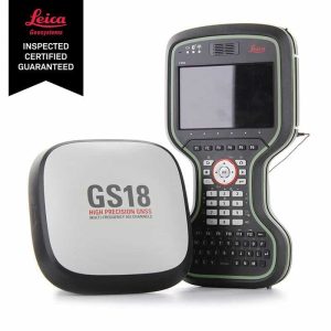
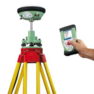
Leica GS18 I GNSS RTK Rover with Visual Positioning
Leica GS18 I GNSS RTK Rover with Visual Positioning
Califf Surveying proudly presents the Leica GS18 I GNSS RTK Rover. This is the first smart GNSS rover that allows you to measure points from images.
Leica Viva GS14
Leica Viva GS14
Leica Viva GS14 is a compact and powerful GNSS smart antenna, suited for any measuring task with integrated mobile communications and UHF modem.

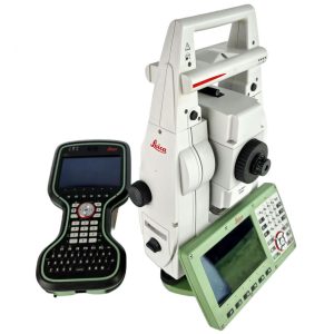
Leica Nova MS50 MultiStation For Surveying
Leica Nova MS50 MultiStation For Surveying
Leica Nova MS50 MultiStation includes precision 3D scanning, extensive and precise total station capabilities, digital imagery, and GNSS connectivity are now brought together in the Leica Nova MultiStation.

Leica TS 12 Robotic Total Station
Leica TS 12 Robotic Total Station
Leica Viva TS12 is a robotic surveying package that will find, lock, and measure up to 1000m with a single keypress.

Leica Nova TM50 Monitoring Total Station
Leica Nova TM50 Monitoring Total Station
Leica Nova TM50 is a unique tachymeter that combines the most efficient measurement technologies in one device. In this way, it opens up completely new dimensions of space around you.
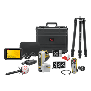
Leica iCON iCS50 Robotic Construction Tool
Leica iCON iCS50 Robotic Construction Tool
If your layout is costing you time, the Leica iCON iCS50 Robotic Construction Tool is the upgrade your crew needs. Built for speed on active sites, it helps you set out points fast, check installs, and capture as-builts with confidence—without dragging the schedule. The iCS50 is made for construction teams who want dependable accuracy, smoother workflows, and fewer call-backs from layout errors. Get it from CALIFF SURVEYING with the right configuration, accessories, and shipping—message us now for current price and stock.

Leica BLK2GO Handheld Imaging 3D Laser Scanner
Leica BLK2GO Handheld Imaging 3D Laser Scanner
The designers created the Leica BLK2GO Handheld Imaging 3D Laser Scanner for surveyors, engineers, and construction workers. It offers fast, accurate, and mobile reality capture.
The BLK2GO is designed to map complex areas in real-time. It uses advanced SLAM technology and a dual-axis LiDAR sensor. This helps create detailed 3D models as you walk.
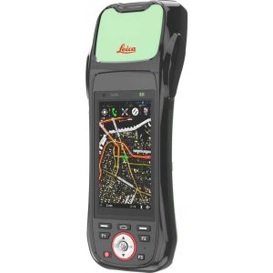
Leica Zeno 20 GIS Collector
Leica Zeno 20 GIS Collector
Zeno 20 is tough and built to last. Lightweight and compact, it fits in one hand, with the largest, best-in-class screen and a dust and water resistance IP67 rating.
Leica iCG70 iCON GPS 70 RTK GNSS Rover
Leica iCG70 iCON GPS 70 RTK GNSS Rover
The combination of the latest GNSS technology and inertial measurement unit (IMU) equips the iCON GPS 70 T with permanent tilt compensation and makes it resistant to any magnetic interference.
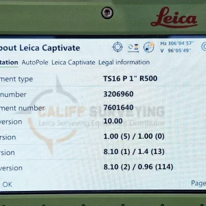
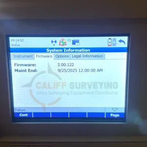
Leica TS16 P 1″ R500 Robotic Total Station CS20
Leica TS16 P 1″ R500 Robotic Total Station CS20
Meet the world’s first self-learning total station. Automatically adjusting to any environmental conditions, the Leica Viva TS16 locks onto your, and only your, target.
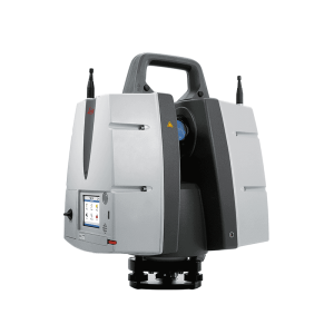
Leica ScanStation P30 3D Laser Scanner
Leica ScanStation P30 3D Laser Scanner
The Leica ScanStation P30 3D Laser Scanner is a terrestrial laser scanning (TLS) solution built for professionals who need reliable accuracy and consistent point cloud quality on real projects. It’s commonly used for as-built documentation, construction verification, topographic mapping, and industrial facility scanning, helping teams capture detailed site conditions for modeling, clash detection, and measurement deliverables.
