Description
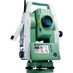
The Leica Nova MS60 MultiStation represents a pinnacle in precision measurement technology, combining the capabilities of a high-end total station with advanced 3D laser scanning functionality. This integration offers unparalleled versatility and efficiency in data collection, making it an invaluable tool for surveying, construction, and engineering professionals. Here’s an overview of its features and benefits:
The new version of Leica Nova MS60, the world’s first MultiStation, enables you to perform all surveying tasks with one instrument. It brings sensor fusion to the next level by combining:
- Highest-end total station capabilities
- 3D laser scanning, enabling you to scan up to 30’000 points per second
- GNSS connectivity
- Digital imaging
Key Features of the Leica Nova MS60 MultiStation:
- High-Precision Surveying: As a total station, the MS60 offers extremely precise angle and distance measurements, suitable for the most demanding surveying tasks.
- 3D Laser Scanning: Equipped with laser scanning capabilities, the MS60 can rapidly capture dense point clouds of its surroundings, providing detailed 3D models for analysis and planning.
- Smart Technology: The MS60 incorporates Leica’s SmartTech features, including automatic target recognition, auto alignment, and tracking, facilitating smooth and efficient operation in the field.
- Versatile Data Collection: This MultiStation seamlessly blends traditional surveying functions with modern laser scanning, allowing for both detailed object capture and expansive area mapping in a single device.
- Long-Range Scanning: The MS60 can perform detailed scans over significant distances, making it suitable for large-scale projects and challenging environments.
- Dynamic Lock and ATR: Features like dynamic lock and ATR (Automatic Target Recognition) enhance the efficiency of surveying processes, especially when working with moving prisms or in challenging conditions.
- Software Integration: The MS60 is compatible with a range of software solutions, such as Leica Captivate and Leica Infinity, allowing for easy data processing, visualization, and export for further analysis or integration into BIM models.
Benefits:
- Efficiency: Combining two powerful surveying instruments into one, the MS60 reduces the need for multiple devices on site, streamlining workflows and saving time.
- Accuracy: With its advanced optics and scanning technology, the MS60 ensures high levels of accuracy in both traditional surveying and 3D scanning modes.
- Flexibility: Its wide range of functions makes the MS60 adaptable to various applications, from detailed architectural surveys to complex construction monitoring and large-scale topographic mapping.
- User-Friendly: Despite its advanced capabilities, the MS60 is designed with an intuitive interface, making it accessible to both experienced professionals and newcomers to 3D laser scanning and surveying.
- Durability: Built to Leica’s high standards, the MS60 is rugged and weather-resistant, capable of operating in harsh environments and under challenging weather conditions.
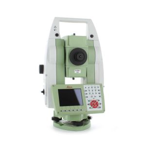
MultiStation 1″ with automatic recognition, Captivate, Imaging, and scanner
First MultiStation in the world, the Leica Nova MS60 combines all available measuring technologies in one superior instrument: continuous adaptation to the surroundings, laser scanning, imaging, long-range measuring without the need for a prism, high accuracy and piezoelectric motorization technology. The Leica Nova MS60 multistation comes with the Captivate software and includes the new self-learning ATR+ technology, providing the most advanced lock-on capability in the world.
The MS60 comes with Leica Captivate, an onboard software with easy-to-use apps that cover all your surveying tasks. To make your work even more productive, you can benefit from the MS60’s Dynamic Lock feature as well as the newly added, revolutionary setup assistant feature, AutoHeight – which helps you set up even faster and more accurately with the simple press of a button.
When to use the Leica Nova MS60:
- Surfaces and volumes in construction and mining: spoil heaps and stockpiles, DTM creation and checking surfaces, material thickness, blast faces, and ground levels
- Analysis of complex structures and objects within plant, marine and utility projects: dimensional control, as-built, and record-keeping
- Measuring buildings and structures: bridge condition/clearance analysis, BIM and as-built
- Façade, elevations and heritage work: the creation of traditional façade deliverables, 3D models and photographic documentation
- Traditional topographic surveys for surveying and mapping: the creation of traditional deliverables like 2D maps or 3D models
- Monitoring measurement and analysis of ground and structures: real-time or periodic measurement of bridges, dams, buildings, and earth, ice and snow
Highest-end total station
Highly accurate angle and distance measurements, long-lasting design, and easy-to-use apps are key elements of modern total stations, fully embodied in the MS60. With improved automation functionalities using ATRplus, the MultiStation increases your efficiency, even under challenging environmental conditions.
3D laser scanning
Scan with up to 30.000 points per second (Hz): complete your scans fast and get dense scanning grids. The MS60 features optimized scanning paths, now including zenith scans, allowing you to significantly reduce the total scanning time.
GNSS connectivity
GNSS is fully integrated into the workflow and the data structure, enabling direct georeferencing. SmartStation and SmartPole setups increase your flexibility in the field.
Digital Imaging
Enhanced digital imaging technology, including an overview and a 30x magnifying telescope camera, enables accurate image assisted surveying both at the instrument and remotely – while also including extended image documentation.
See what our customer has to say about tying the MS60 into a perfect workflow:
Leica Nova MS60 Specifications
| ANGLE MEASUREMENT | ||
| Accuracy Hz and V | Absolute, continuous, quadruple | 1” (0.3 mgon) |
| DISTANCE MEASUREMENT | ||
| Range / Accuracy / Measurement time | – Prism (GPR1, GPH1P)– Single (any surface) | 1.5m to >10,000m / 1mm + 1.5ppm / typ. 1.5s1.5m to 2,000m / 2mm + 2ppm / typ. 1.5s |
| Measurement technology | Wave Form Digitising | Coaxial, visible red laser, dot size 8mm x 20mm @ 50m |
| IMAGING | ||
| Overview and telescope camera | – Resolution / Frame rate– Field of view (overview / telescope) | 5 MPx CMOS / up to 20 fps19.4° / 1.5° |
| GENERAL | ||
| Operating system / Field software | Windows EC7 / Leica Captivate and its apps, supports onsite and realtime decisions | |
| Processor | TI OMAP4430 1GHz Dual-core ARM® Cortex™- A9 MPCore™ | |
| Autofocus telescope | Magnification / Focus Range | 30 x / 1.7m to infinity |
| AutoHeight Module | – Distance accuracy– Distance range | 1.0 mm (1 Sigma)0.7 m to 2.7 m |
| Display and keyboard | 5“ (inch), WVGA, colour, touch, both faces | 37 keys, illumination |
| Operation | 3x endless drives, 1x Servofocus drive, 2x Autofocus keys, user-definable SmartKey | |
| Power management | Exchangeable Lithium-Ion battery | Up to 9h, internal charging capability |
| Data storage | Internal memory / Memory card | 2 GB / SD card 1 GB or 8 GB |
| Interfaces | RS232, USB, Bluetooth®, WLAN | |
| Weight | MultiStation including battery | 7.7kg |
| Environmental specifications | – Working temperature range– Dust & Water (IEC 60529) / Blowing rain – Humidity | –20°C to +50°CIP65 / MIL-STD-810G, Methods 506.5 I and 507.5 95%, non-condensing |
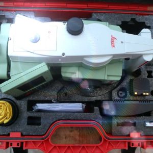
Leica Nova MS60 includes:
- Leica MS60 1″ (0.3mgon), MultiStation
- Reflectorless EDM (R2000) and high-speed 1000Hz EDM
- Captivate software- Measure & Stakeout
- The automatic target recognition,
- PowerSearch,
- 5MP imaging, overview camera,
- 30x telescope camera,
- Autofocus,
- WLAN,
- Bluetooth,
- RS232/USB interface,
- RadioHandle interface,
- USB stick/SD card interface,
- 2GB eMMC Flash Memory,
- 1GB SDRAM, 2 keyboards with 5″ WVGA color touch screen,
- Laser plummet,
- GEB242 batteries (2)
- GKL341 Pro Charger
- SD Memory card 8GB
- GDF321 Tribrach
- Quick Guide
- upright container.
- Leica Captivate – Measure & Stakeout for CS20
- 2 each – GKL311 Pro Charger. Charges one Battery, including power cable
- 2 each – GDF321, Professional Tribrach without Optical Plummet
- Manufacturer: Leica
- Model: Nova MS60
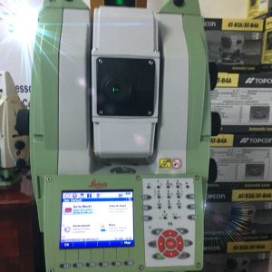
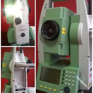
- Used: The item has been previously owned and operated. It is not a brand-new piece of equipment but has been utilized for some period by a previous owner or owners.
- Great Working Condition: Despite being used, the scanner is in excellent operational state. This indicates that all functions and features of the Leica Nova MS6 are working as intended, without any significant defects or operational issues. It should perform to the standards expected for surveying, engineering, and construction projects, offering the high precision, accuracy, and reliability associated with the brand.
- Ready to Use: The item is set for immediate application without the need for repairs or extensive maintenance. This implies that the necessary calibration, software updates, or minor refurbishments, if any were required, have been completed. The buyer can start using the scanner for 3D laser scanning tasks right away.
Reference Library
Leica Nova MS60 MultiStation Manufacturer Information
Leica Nova MS60 MultiStation Brochure